Copyright ©2000-2011
The content of this site, including the
text and photographs, are the exclusive property of Steve Fredrick.
This means you are welcome to view and enjoy; however, you do NOT have
rights to copy, store, print, or republish any of the content without the
written permission of Steve Fredrick.
Let me know what you think about the site or the images. Send me an email .
Death Valley NP
October 2009
|
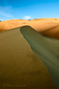
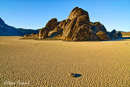
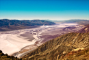
During the summer the temperatures in Death Valley are oppressive (100° F for the low is not uncommon). So late fall, winter and early spring are the best times to visit Death Valley. I had not been to DV before so I did some of research to come up with a preliminary shoot list and schedule for the areas I wanted to visit under what lighting conditions. This list was modified based on findings and weather conditions when actually there. The two places highest on my list were a couple of sand dune areas (Mesquite Flats and Eureka) and a remote place called the Race Track Playa. So I selected a flight into Las Vegas that would allow us to get to Death Valley by sunset. I was hoping to make it to Mesquite Flats for sunset. Well....we were a little late leaving Las Vegas (flight and new rental car pick up procedure) and as we were driving into the East Entrance of park it was obvious we were not going to make it across to Mesquite Flats. So we stopped and shot along the road (some of these images are at the beginning of the Rock and Light Gallery. As soon as the sun dropped below the mountains the light along the east entrance was gone. But we did make it to Zebriskie Point while there was still some color left in the sky. In fact we shot several sunrises and sunsets from Zebriskie. These images are what makes up the rest of the Rock and Light Gallery. For the first few days that we were there, the wind was really blowing, I'd guess in the 30-40 mph range. This mean two things: (1) going to the sand dunes while the wind was blowing was out of the question but (2) when we did get there all the foot prints since the last wind storm would be covered over. The bulk of the images in the Sand Gallery are from several trips to Mesquite Flats. (It took a long dive to get to the Eurka sand dunes and the light was disappointing. However, I made one of my favorite images of the trip there. It's the first one in the Sand Gallery.) While the wind was blowing hard a dust haze hung over the valley from all the sand being picked up. This can be seen in several of the images in the Salt Gallery. By far the hardest place to get to was the Race Track Playa. It took the better part of three hours to drive the 26 miles (each way) over the horribly washboarded road. The attraction at the Race Track is the moving rocks (Wikipedia reference). Fortunately the light cooperated and we were able to use the low light levels to accentuate the rock's trails. (It's unfortunate but it appears that as more and more people visit the area some of them are "messing" with the rocks. We saw tracks without rocks and one trail that has two rocks, one at beginning and one at it's end. And at least one instance where it appeared that someone had tried to create a fake trail.) As the light drop behind the Panamint Mountains we lost the light on the rocks but it lit up the rock formation at the north end of the mud flat, called the Grandstand, with beautiful light (as the almost full moon rose). See the Race Track Playa Gallery . Between planned shooting locations at sunrise and sunset we explored different areas of the park. But the way, Death Valley NP is the largest Nation Park in the lower 48 and is about the size of Connecticut. I put a few of these images in the Sense of Place Gallery.
|
|
 Rock and Light |
|